Name |
Nam Phui (also spelt Nam Poui). Abbreviated: NPI |
Status |
Established by PM Decree 164, 29 October 1993. Name and area change to Nam Phoun proposed in 1995, but never adopted and no longer recommended |
Location |
Location Latitude: 18o 12' - 18o 58'N
Longitude: 101o 04' - 101o32'E |
Map Sheets |
Scale I: 100,000
Scale I: 200,000
Scale I: 500,000
|
Provinces |
Sayaburi |
Districts |
Piang (60%)
Paklay (10%)
Thong Mixai (30%) |
Perimeter |
200 km (check with GIS) |
Boundaries |
Northern boundary follows watershed of Nam Song and abuts the Nam Tan Provincial Protection Forest . Eastern border follows base of an escarpment for c. 60 km from B. Nam Poui in the north to Thai border at B. Houey Khao in the south. Proposed extension would bring eastern boundary to the main road at B. Nakannyang. Western boundary follows border with Thailand for c. 55 km. and in the southwest excludes 17 villages in Thong Mixai District. |
Area |
As decreed: 1912 sq. km
As proposed in Berkmüller et al. (1995): 1.150 sq. km - never implemented
Decreed boundaries re-measured: 1,757 sq. km (Flint and Chanthavong, 1998) |
Proposed
Extensions |
20 km of eastern boundary centered on B. Vangpamon extends to Nam Nguan at
B. Nakannyang. This would add 108 km2 , making total area including currently proposed extension: 1,866 km2 |
Access |
From the main Sayaburi-Paklay highway, there are roads leading in to the NBCA southwest from B. Nam Phui , via Pak Song to B. Navene and westwards from Pak Lay to Thong Mixai. The military has almost completed (1999) a track from B. Navene south to B. Dan in Thongmixai and from B. Navene to the Thai border. Access to both is to be strictly controlled. B. Vangpamon and other villages on the eastern boundary may be reached by seasonal tracks. The Thai border with the NBCA is a closed area controlled by the military.
|
Stakeholder
Villages &
Population |
| |
|
No. of villages by type |
|
| District |
Villages |
I |
II |
III |
IV |
Persons |
| Piang |
17 |
4 |
5 |
5 |
3 |
,233 |
| Paklay |
18 |
1 |
6 |
9 |
2 |
10,202 |
| Thongmixay |
10 |
0 |
7 |
1 |
2 |
5,121 |
| TOTAL |
45 |
5 |
18 |
15 |
7 |
24,556 |
|
Principal Local
Resource
Uses |
|
Ethnic
Composition |
All but three of the 45 stakeholder villages are predominantly inhabited by Lao Lum. The exceptions are B. Na Samphan (Lao Theung) and B. Na Ngern (Lao Sung) in the B. Navene complex, and B. Yarp, which is also a Hmong community. There is also a small group of nomadic Malabri (a Vietic-speaking) people that inhabit the NBCA and occasionally come out to trade with surrounding villages.
|
|
1989 |
Border war fought in parts of what is now the NBCA. Area considered "sensitive" since then with a Provincial Army Contingent based at B. Na Samphan and scattered field camps. |
1991 |
Ban Navene Rural Development Project begun resettling immigrants from other provinces at an existing Lao Lum village close to the border. Immigration encouraged until 1994, continuing informally until about 1996. |
1993 |
NBCA declared and management team established with support under Lao-Swedish Forestry Programme (Phase III) |
1995 |
Production of a simple Management Plan |
1996-2000 |
Support continues under LSFP IV |
1996 |
Field Office opened at B. Nakannyang |
1997 |
Wildlife survey training |
1998 |
Training in wildlife survey techniques and participatory management |
1997-2000 |
Intensive land-use planning, population surveys and extension activity at B. Navene, led by NOFIP/LSFP Land-use Planning Sub-programme. |
1997-2000 |
Checkpoints established at B. Nakannyang (1997) and B. Paksong (1999)
|
|
Physical
Features |
Steep and rugged ridges mostly of Mesozoic sandstones and shales trending strongly NNE. The eastern ridge rises from lowlands at c. 400m to a crest at 700-1000 m. Limestone outcrops occur in places along the base of this ridge. Summits along the Thai border are higher to a maximum of 1790m. Three rivers drain eastwards to the Mekong : Nam Phui, N. Phoun and N. Lai. |
Elevation |
200m - 1790 m |
Climate |
Distinctly cool, dry winters, typical of northern provinces . Hot, dry season in March-April carries high risk of forest fires. Annual rainfall estimated 1,500 - 2,000 mm, with pronounced local rain-shadow effects. Elevated western parts of the NBCA and central eastern villages, like B. Nakannyang, appear to have higher rainfall than around B. Nam Phui and B. Navene in the north and along the Mekong valley at Pak Lai. |
Main Forest
Types |
Majority of NBCA is Mixed Deciduous Forest dominated by bamboo as a result of regular burning. Afzelia locally dominant in upper canopy. Teak also present at lower elevations. Seasonal evergreen forests occur along rivers, along the border hills and in parts of the north central region south of B. Navene. Some of these areas fit Vidal's (1960) description of an Annonaceae-Meliaceae-Sapindaceae forest type.
(Add a pie diagram of habitat types, based on MRC forest cover analysis with NBCA boundary overlays) |
Other Habitat
Features |
At least 33 mineral licks scattered throughout the NBCA (Boonratana, 1998). A shallow 1 ha lake , Nong Xei, occurs 7 km south of B. Navene.
|
Vertebrate
class |
No. of species |
No. Key species |
|
|
Mammals |
50 |
29 |
|
Birds |
70 |
5 |
|
|
Reptiles |
13 |
7 |
|
|
Amphibians |
2 |
0 |
|
|
Fish |
19 |
? |
Note: only figures in bold text considered result of adequate survey.
|
|
Biodiversity
Values |
Substantial elephant population, estimated at 350 wild animals plus similar number of domestic elephants in the three surrounding districts. Possibly the largest contiguous elephant population in Laos and thus of regional significance.
-
Only NBCA located on west bank of Mekong and thus including Thai faunal elements, such as lar gibbon, Hylobates lar. Only NBCA protecting Annonaceae-Meliaceae-Sapindaceae type of semi- evergreen forest, which includes a species, Chukrasia tabularis (Meliaceae) with recently identified plantation potential (FORSPA, 1998).
-
Mixed deciduous forests contain easternmost native teak forests in the world (in proposed eastern extension). These are important breeding stock.
-
Significant and potentially viable populations of gaur, tiger, dhole, serow and Asiatic black bear.
-
Recent evidence that Sumatran rhino may still exist there (but almost certainly not a viable population).
-
Record of silvered langur, Presbytis cristata, that apparently extends species known range northwards by several hundred kilometers.
|
Watershed
Values |
Provides source for three permanent rivers which supply domestic use and minor irrigation schemes in Piang and Pak Lay Districts. |
Cultural
Values |
A small population of Malabri people, who speak a Vietic-language and follow a hunter-gather economy. |
Security
Values |
Relatively unpopulated NBCA with security significance following border incursions in 1989. Strong military presence.
-
Settlements at B. Navene established in 1991 partly for security reasons as a Provincial Focal Development Site.
|
Recreation &
Tourism
Values |
Good quality forests readily accessible from a major highway linking the Thai border at Kentao with Luang Phabang. Guest house facilities at B. Nakannyang. Potential for trekking and elephant hire. |
Principal
Threats |
Widespread forest fires each dry season progressively converting evergreen to mixed deciduous forest types.
-
Likely impacts of vehicle tracks currently under construction by the military
-
Immigration and agricultural encroachment in B. Navene area
-
NTFP collection and hunting from Thongmixai district
-
Hunting by the military inside the NBCA
-
Collection of residual timber from peripheral areas of the NBCA
|
Reasons for
proposed
Extensions or
Excisions |
Inclusion of lowland areas adjacent to Field Office at B. Nakannyang adds good populations of wildlife, significant examples of teak forest and Annonaceae-Meliaceae-Sapindaceae forest. Aslo, good tourism potential in these areas adjacent to the road.
-
Berkmüller et al. (1995) proposed excision of northern quarter of the reserve on grounds of extensive shifting cultivation and centered on B. Navene. This is no longer recommended because: 1. Strong efforts are being made to stabilize land-use around B. Navene. 2. The northern border areas are reported to have remaining elephant populations and mineral licks that are used seasonally. 3. Desirable to keep Nam Phui NBCA contiguous with Nam Tan Protection Forest as a single extensive block of forest adjacent to the border.
|
|
Contact |
Mr. Sut Searn, Head of Nam Phui NBCA,
C/o Provincial Agriculture and Forestry Office, Sayaburi. Tel.074-412076 |
Staffing |
15 staff (13 male, 2 female), 11 based at Field Office, B. Nakannyang, and one each in the three DAFOs and at B. Navene |
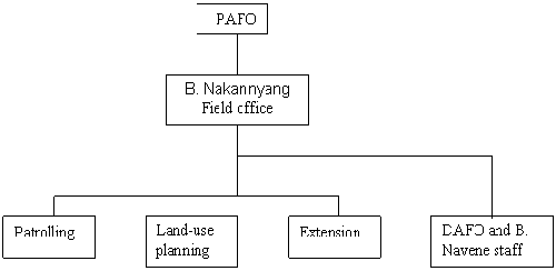
Organization |
| 
|
Buildings |
Field office and staff accommodation at B. Nakannyang constructed 1996, beside the Pak Lai-Sayaburi highway. "Governor's resthouse" (two units of two-bedroom chalets) constructed on other side of road beside N. Gnam. Check-gate on the road operated since 1997. Other check-gates and accommmodation constructed at Pak Song (1999) and B. Dan (2000). |
Equipment |
4 motorcycles (one pick-up and 6 more m/bikes on order, 1999). Basic sets of guide books, maps, compass, binoculars, camping kit and a computer. B. Nakannyang has a small generator. |
Financial
Support and
Training |
Financial support from Sida through Lao-Swedish Forestry Programme: 1991-2000.
Annual budget FY 1999-2000: 60,000,000 Kip
Advisor input: Occasional from Conservation Advisers 1993-1999 and LUP Advisor 1996-2000
Short-term training: wildlife survey (3 mo., 1997, 2 mo, 1998)
Participatory management (2 mo, 1998) |
Current
Management
Priorities |
Complete village co-management agreements with all surrounding villages
-
Establishment of effective control gates at both ends of the military track linking B. Navene and Thong Mixai. Prevent the other track from B. navene to the border from being opened to cross-border trade.
-
Establish effective conservation unit in the Sayaburi Provincial Army units based in the NBCA.
-
Livelihood development activities focused in B. Navene, Thong Mixai and selected villages on the eastern border.
-
Competent bird survey to determine comparative similarity of Nam Phui other protected areas in northern and central Laos and in northern Thailand .
|
Other
Management
Opportunities |
Significant potential for ecotourism development using existing Governor's bungalows at NBCA Field Office, B. Nakannyang, and adjacent nature trail walk with potential expansion to B. Vangpamon. Also, to construct information centre for local visitors at B. Nakannyang vehicle check-point.
-
Stabilization of forest clearance and agriculture in the B. Navene Rural Development Project area, following support for land-use planning under LSFP IV.
-
Research on both wild and domestic elephants
-
Implement the proposed extension of the NBCA through lowlands to B. Nakannyang and B. Ponsak.
-
Improved cooperation with provincial authorities on Thai side of border.
|
Other Relevant
Project
Initiatives |
UNDP Co-ordination Office, Sayaburi
-
UNCDF/UNDP Nam Tan Sustainable Watershed Management Project
-
CARE/Netherlands Paklay Forest Conservation and Livelihood Security Project
-
UNDP Aquaculture Development Project
-
UNDP Integrated Rural Accessibility Planning Project
|
|
Anon. (1995). Management Plan for Nam Phui NBCA (1995). LSFP, Sayaburi.
Boonratana, R. (1997). Field Training in Wildlife Conservation Research Techniques and Large Mammal Survey at Nam Phui NBCA. LSFP/IUCN, Vientiane
Boonratana, R. (1998). Field Management of Nam Poui and Phou Xang He NBCAs. LSFP/ IUCN, Vientiane .
CARE International (1997). Paklay Forest Conservation and Livelihood Security Project. Project proposal for Netherlands Government. DARE, Vientaine.
Flint , C. A. and Chantavong, K. (1998). Participatory Protected Area Management in Nam Phui and Phu Xang He protected areas. LSFP/IUCN, Vientiane .
FORSPA (1998). Teak Plantation Improvement and Gene Conservation in Lao PDR. FO: GCP/RAS/163/NET Field Document No. 11. FAO Regional Office for Asia and the Pacific, Bangkok .
Integrated Rural Accessibility Planning (IRAP) (1998). District Accessibility Profile: Paklay District. IRAP Sayabouly with Rural Development Committee. MCTPC/UNDP Project Lao/95/001, Sayabouly.
IUCN (1999). Rural Development, Natural Resource Planning and Biodiversity Conservation in Sayaburi Province , Lao PDR: a proposal for integrated management of Nam Phui NBCA. IUCN, Vientiane
Jones, P. R. (1998-1999). Reports on Phases 1,2, and 3 of a Land Use Planning Exercise in the Villages of B. Navene, B. Na Ngeun and B. Na Samphan, Peng District. Unpublished LSFP/NOFIP, Vientiane .
Lair, R. C. (1997). Gone Astray: the Care and Management of the Asian Elephant in Domesticity. FAO Regional Office for Asia and the Pacific (RAP) Publication 1997/16. Bangkok .
Marsh, C. W. (1997-99). Advisers Field Trip Reports to Nam Phui NBCA, Nos. 8, 9 and 10. Unpublished, LSFP/CPAWM, DoF.
Srikosamatara, S., Sirripholdej, B. and Suteethorn, V. (1992). Wildlife Trade in Lao PDR and Between Lao PDR and Thailand . Natural History Bulletin of Siam Society 40:1-47.
UNDP (1996). Socio-economic Profile of Sayabury Province. Lao PDR: Province Profiles Series No. 2. Rural Development Programme Formulation, UNDP, Vientiane .
UNCDF/UNDP (May, 1998). Nam Tan Sustainable Watershed Management: Project Document. UNDP, Vientiane .
Vidal, J. (1960). La Vegetation du Laos (Parts I and II). Travaux du Laboratoire Forestier de Toulouse, Toulouse . |
go up |
|