|
| Name |
Phu Xang He; Abbreviated: PXH |
| Status |
Established by PM Decree 164, 29 October 2024 |
| Location |
Latitude: 16o 42' - 17o 04'N
Longitude: 105o 19' - 106o 06'E. |
| Map Sheets |
Scale I:
Scale I:
Scale I: 500,000
|
| Provinces |
Savannakhet |
| Districts |
Atsapon 30%
Palansai 22%
Phin 10%
Xepon 4%
Vilabouri 34% |
| Perimeter |
|
| Boundaries |
|
| Area |
1060 km² as decreed, (LSFP, 1995).
1100 km2 as recognised by CPAWM.
1180 km2 as estimated from current maps.
?? km2 as estimated from GIS spatial data.
1299 km2 including proposed extension. |
Proposed
Extensions or
Excisions |
For the most part, the boundary of PXH is easily discernible as where the land starts to rise at the base of the Phu Xang He and Phu Hinho-Katon hills. The only
exception to this is the corridor between these two groups of hills which is bounded to the north by the Dong Xebay forest and to the south by the Huai Alom and Huai Xeloun creeks. The NBCA boundary follows the Sai Phu Xang He escarpment for most of its northern length, it is bounded by the Xe Namkok River to the east and to the south by the Huai Thingalong creek in Palansai and the Palanhin Phoutakouan darns in Atsapon.
The proposed extension would incorporate the entire Dong Mai Khaen Phalam Forest in Atsapon district up to the western extremity where it meets the Huai Xetouk creek.
There is a proposed extension of 117 km2 to the West and South of the current western extremity of the NBCA in Atsapon district. For management purposes, this proposed extension is already treated as part of the NBCA and is recognised as such by the twenty villages which exercise traditional use rights over the area.
|
| Access |
Phu Xang He is accessible from the South for its entire length via numerous
tracks and paths leading from National Route 9. Its northern border can be reached from the road between Mahaxai and Vilabouri but the NBCA itself is largely inaccessible from this direction due to steep escarpments. Access to the corridor zone is possible from Vilabouri to the North and Xetamouak to the South, but vehicular traffic is limited to the dry season. Access to the Phu Hinho-Katok hills is possible from the North and the East by the road between Xepon and Vilabouri. Access by river is possible in some areas, but only during the wet season and only for quite short distances into the NBCA.
Access to the NBCA will increase markedly post 2000 with the completion of a number of planned or on-going road projects. Access from Vilabouri and the North will be eased with the new road from Mahaxai, as will access from the East when the on-going improvements to the Xepon-Vilabouri road are completed. The planned upgrading of Route 9 will not only improve access from the South, but will also increase the potential for trade in forest products by providing better links with both Vietnam and Thailand. |
| Stakeholder
Villages &
Population |
|
District |
Villages |
Village type |
Population |
|
|
|
I |
II |
III |
IV |
|
Atsapon |
48 |
1 |
13 |
14 |
20 |
|
|
Palansai |
13 |
0 |
7 |
1 |
5 |
|
|
Phin |
11 |
1 |
3 |
3 |
4 |
|
|
Xepon |
13 |
0 |
7 |
2 |
4 |
|
|
Vilabouri |
32 |
8 |
19 |
1 |
4 |
|
TOTAL |
117 |
10 |
49 |
21 |
37 |
|
|
| Principal Local
Resource
Uses |
|
| Ethnic
Composition |
PXH guardian villages are either Lao Lum or Lao Theung. Phu Tai account entirely for the former group, while Lao Theung include the Mon Kong, Suai and Katang groups. Neither Lao Sung nor Ethnic Lao are represented. Livelihood systems of these groups are paddy rice based, with some livestock raising supported by hunting, fishing and NTFP collection from the NBCA.
|
| 1992 |
Reconnaissance survey conducted by DoF |
| 1993 |
Phu Xang He NBCA established
Wildlife and habitat survey
Aerial photographs taken |
| 1994 |
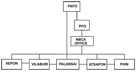
NBCA resposibility given to Provincial Porestry Office (PAFO) |
| 1995 |
First annual activity plan
Village socio-economic surveys
Village credit program (SIDA)
NBCA staff in province and districts |
| 1996 |
First annual plan implemented
First land use planning conducted
Awareness activities in 10 villages |
| 1997 |
Basic training for NBCA staff
Three districts receive management budget
PRA training for NBCA staff |
| 1998 |
Participatory conservation training
Management training for NBCA staff
Long-term advisor attached to PXH
Aerial photos procured |
| 1999 |
Provincial PXH office established
First village development program
Eco-tourism survey conducted
First conservation network established |
|
|
| Physical
Features |
Topographically PXH comprises two NW-SE oriented hills, the Sai Phu Xang He and Sai Phu Hino-Katon. To the North and Northeast the Sai Phu Xang He range is dominated by a steep sandstone escarpment, while slopes to the South and the West rise more gently to the plateau. Sandstone outcrops or darns occur throughout the NBCA and can be quite extensive particularly on the southern aspects of the Sai Phu Xang He range.
The NBCA contains no standing water bodies and many of its creeks and small rivers are highly seasonal. Indeed, the plateau and higher slopes are extremely arid in the dry season and many large mammals are forced to migrate to lower elevations for water at that time. The NBCA is drained to the South by the Xe Xangxoy, Xe Thamouak and the Xe Champhon rivers and to the North by the Xe Bay and the Xe Noy rivers. PXH is somewhat unique in the presence of a lowland area between the Sai Phu Xang He and the Sai Phu Hinho-Katon hills which acts as an important corridor for wildlife migration between the 2 hills. Although still largely forested, the corridor zone has been settled and contains 8 enclave or type I villages. |
| Elevation |
|
| Climate |
Climate in PXH is dominated by the SW and NE monsoons which produce three distinct seasons: cool dry (November-February), hot dry (March-May) and a wet season under the influence of the southwest monsoon (June-October)
From December - January strong northerly winds from North Vietnam blow across the NBCA further reducing temperatures to a mean minimum of 14 0 C during this period. |
| Main Forest Types |
Evergreen Forest 41 %
Dry Dipterocarp 7 %
Mixed Decidous 44 %
Farming 6 %
Other 2 % |
| Other
Habitat
Features |
|
|
|
| Recorded
Vertebrates |
| Common Name |
Scientific Name |
Importance |
Status |
| Asian Elephant |
Elephas maximus |
|
P |
| Giant Muntjack |
Megamuntiacus muntjak |
|
P |
| Gaur |
Bos gaurus |
|
P |
| Banteng |
Bos javanicus |
|
P |
| Lesser Slow Loris |
Nycticebus coucang |
VH |
VC |
| Pygmy Loris |
Nycticebus pygmaeus |
V |
C |
| Douc Langur |
Pygathrix nemaeus |
|
F |
| Gibbons |
Hylobates ssp. |
VH |
F |
| Asiatic Black Bear |
Selenarctos thibetanus |
|
P |
| Sun Bear |
Ursus malayanus |
|
P |
| Tiger |
Panthera tigris |
VH |
P |
| Leopard |
Panthera pardus |
|
P |
| Large-spotted Civet |
Viverra megaspila |
VH |
P |
| Asian Wild Dog (Dhole) |
Cuon alpinus |
|
P |
| Common Name |
Scientific Name |
Importance |
Status |
| Siamese Fireback |
Lophura diardi |
|
C |
| Red-collared Woodpecker |
Picus rabieri |
T |
F |
| Black-headed Woodpecker |
Picus erythropygius |
|
C |
| Pale-headed Woodpecker |
Gecinulus grantia |
|
P |
| Grey Peacock Pheasant |
Polyplectron bicalcaratum |
|
P |
| Bar-backed Partridge |
Aboriphilia brunneopectus |
|
C |
| Ruddy Kingfisher |
Halycon coromanda |
|
P |
| Brown Hornbill |
Ptilolaemus tickelli |
|
P |
| Wreathed Hornbill |
Rhyticeros undulatus |
|
S |
| Red-vented Barbet |
Megalaima lagrandieri |
NT |
C |
| Bar-bellied Pitta |
Pitta ellioti |
T |
C |
| Ratchet-tailed Treepie |
Temnurus temnurus |
NT |
S |
| Grey-faced Tit-babbler |
Macronous kelleyi |
NT |
C |
| Rufous-throated Fulvetta |
Alcippe rufogularis |
NT |
C |
| Mountain Fulvetta |
Alcippe poioicephala |
AR |
P |
| Golden-crested Mynah |
Ampeliceps coronatus |
|
F |
Notes :
Importance: AR = at-risk T = threatened NT = near-threatened V = vulnerable
VH = very high conservation value
Status: S = scarce P = present F = frequent C = common VC = very common |
| |
|
|
| Biodiversity
Values |
• Phu Xang He contains many species of globally threatened large mammals including elephants, cattle, big cats and bears, all of which require large areas
of undisturbed habitat for their survival. The sheer size of PXH and its
relatively pristine state means that it is of major national and regional importance in supporting these species.
• The presence of five species of higher primates in PXH is of significant importance. The three with the highest conservation priority, Francois's Langur
( Semnopithecus francoisi ), Douc Langur ( Pygathrix nemaeus ) and the Black
Gibbon ( Hylobates concolor ), are all common throughout the NBCA. The
other two species are macaques.
• Populations of Tiger ( Panthera tigris ), Leopard ( Panthera pardus ), Clouded Leopard ( Neofelis nebulosa ) and Large spotted Civet ( Viverra megaspila ) are present in the NBCA.
• Elephants ( Elephas maximus ) are commonly observed and populations are currently estimated to number between 40 and 50 individuals.
• Pygmy Loris ( Nycticebus pygmaeus ) and the lesser Slow Loris ( N. coucang ) are common throughout the NBCA. PXH contains 7 species of globally threatened or near threatened bird species, most notably the Bar Bellied Pitta ( Pitta ellioti ). The Phu Hinho-Katok hills at the eastern extremity of the NBCA are particularly important in terms of bird species richness. |
| Watershed
Values |
• Four out of five of Savannaket's major watersheds have their head-waters in PXH and hence the NBCA plays a key role in maintaining the integrity of the province's critical upper watersheds. Given Savannaket's position as the country's leading rice producer, the sustainable management of these upper watersheds is of the highest strategic importance from a national food security standpoint.
• To the North, PXH contains the Xebay watershed, the major tributary of the Xe Bangfai which drains the northern part of Savannaket, eventually flowing into the Mekong near the border with Khamouane.
• In the South, the NBCA contains the headwaters of the Xe Champon, the Xe Xangxoy and the Xe Thamouak, and to the East, also contributes to the Xe Bang Hiang. These 4 watersheds drain the entire central and southern portions of Savannaket province, supporting numerous irrigation systems. The head-waters of these major river systems in PXH are important breeding grounds for many of the migratory fish species which inhabit the Mekong River and its major tributaries. |
Security
Values |
|
| Cultural
Values |
Darn Mon, a significant religious site in PXH, receives many Buddhist visitors and is host to a locally important religious ceremony each year in ??. |
| Recreation
and Tourism
Values |
PXH is strategically placed to the North of Route 9, a major East-West tourist route between Thailand and Vietnam . A survey of foreign tourists who traveled this route, revealed a high level of interest in various forms of nature tourism in the NBCA. |
| Principal
Threats |
• Extreme poverty is forcing guardian villagers into hunting and non-sustainable NTFP extraction from the NBCA.
• Habitat-loss caused mainly by agricultural land expansion in village types I and II is of particular concern in the corridor and the proposed extension areas.
• National and provincial concession holders for timber, rattan and Naman Yang, etc. are increasingly attempting to encroach into the NBCA as such resources become scarce elsewhere.
• Lack of inter-village coordination, poor community organisation and low levels of empowerment make most guardian villages powerless to deal with threats external to their own community.
• On-going or planned road development is increasing opportunities for illegal trade in wildlife and forest products.
• Fire occurs each year in the mixed deciduous forest areas of PXH and indications are that this may be slowly eroding adjoining areas of dry evergreen forest. |
| Reasons for
Proposed
Extensions or
Excisions |
|
| Contact |
Mr. Phoukong Soungnawongsa. Tel. 041 212941
Provincial Agriculture and Forestry Office Fax. 041 212941
Savannaket Email [email protected] |
| Staffing |
Provincial staff: 3, District staff: 10, Advisor: 1 |
| Organization |
|
| Buildings |
1 provincial NBCA Office in Savannaket, no field offices |
| Equipment |
5 motorcycles (on order)
1 4x4 pick-up and 5 additional motorcycles (on order)
GPS, compass, binoculars, camping and patrol equipment is available for use on a loan basis from the Provincial NBCA Office.
Camping, cooking and trekking equipment for eco-tourism groups of up to 10 people is maintained at the NBCA Office. |
| Financial
Support &
Training |
Financial support from Sida through the Lao Swedish Forestry Programme (LSFP) from 1990-2000.
Annual budget 60,000,000 Kip (FY 1999-00).
Technical support from IUCN through LSFP. |
| Current
Management
Priorities |
Upgrading provincial government capacity in natural resources management and development planning.
-
Participatory conservation management methods development.
-
Guardian village livelihood development activities.
-
Networking of NBCA guardian villages.
-
Public awareness and family planning programs.
-
Development of community-based nature tourism activities.
-
Development of a user-oriented NBCA management information system.
|
| Other
Management
Opportunities |
|
| Other Relevant
Project
Intiatives |
|
| |
Anon. (1998). Socio-Economic Profile of Savannaket Province . Lao PDR Province Profiles Series
Anon. (1999 No. 5. UNDP, Vientiane. ). Information Brochure for Phu Xang He NBCA. LSFP/IUCN, Vientiane . (In Preparation).
Anon. (1999). National Study on the Socio-Economic Impact of Unexploded Ordnance, Savannaket Province and District Report. Handicap International, Vientiane .
Boonratana, R. (1998). Field Management of Nam Phui and Phu Xang He National Biodiversity Conservation Areas. LSFP/IUCN, Vientiane .
Craig, I. A. (1998-99). Monthly Progress Reports of the Long-Term Conservation Advisor to PXH. LSFP/IUCN, Savannaket.
Craig, I. A. (1999). Annual Analytical Report, Field Conservation Advisor. LSFP/IUCN, Vientiane .
Craig, I. A. (1999). A Proposed Fisheries Conservation Program: Namuang, Atsapon District. Unpublished Report LSFP/IUCN, Savannaket.
Craig, I. A. (1999). Participatory Natural Resources Management and Conservation in the Lao PDR: Key Issues and Technical Support Needs. Advisor's Inception Report. LSFP/IUCN, Vientiane .
Craig, I. A. (1999). Survey on the Potential for Community-Based Eco-tourism in Savannaket. Unpublished Report, IUCN/LSFP, Savannaket.
Duckworth, J. W., Timmins , R. J. and Cozza, K. (1993). A Wildlife and Habitat Survey of Phu Xang He Proposed Protected Area. LSFP/IUCN, Vientiane .
Flint , C.A. and Chantavong, K. (1998). Participatory Protected Area Management in Nam Phui and Phu Xang He. (2 vols.) LSFP/IUCN, Vientiane .
Jones, P. R. (1999). Report on Land Use Planning in the Villages of Ban Katep, Ban Som Sanuk and Ban Non Samlan, Vilabouri District, Phu Xang He NBCA, Savannaket Province . Unpublished Report, LSFP, Vientiane .
Phanthavong, B. and Dobias, R. (1993). Draft Management Framework for Phu Xang He. DOF, Vientiane .
Sengsavanh, V. and Evans, T. (1997). A Consultancy to Support Management of Phu Xang He and Xe Bang Nouan Protected Areas, Final Report. LSFP/IUCN, Vientiane . |
|
|