|
Name |
Dong Phou Vieng. Abbreviated: DPV |
Status |
Established by PM Decree, 7 July 2024 (western part, 53.000 ha)
Extended by PM Decree 579, 21 May 2024 to a total of 197.000 ha |
Location |
Latitude: 1607’ - 1644’ N
Longitude: 10551’ - 10632’ E |
Map Sheets |
Scale I: 50,000
6142 II |
6242 III |
6242 II |
6342 III |
6141 I |
6241 IV |
6241 I |
6341 IV |
- |
6241 III |
6241 II |
6341 III |
|
|
Scale I: 100,000
- |
E 48-117 |
- |
E 48-128 |
E 48-129 |
- |
E 48-141 |
E 48-141 |
E 48-142 |
|
|
Scale I: 250,000
|
|
Scale I: 1.000.000 |
|
|
Province |
Savannakhet |
Districts |
Phin
Xepon
Nong |
Perimeter |
km |
Boundaries |
In the southwest of Dong Phou Vieng NBCA the western boundary runs along aroad leading from Ban Khe-Tai to Ban Bok. It continues along the Xe Kamouak until the mouth of Houay Ketxan.
The northern boundary runs along the Houay Ketxan and the Xe Chon till Ban Kammakon. Here it turns south still going up the Xe Chon and then crossing the mountains till it reaches the Xe Banghiang. It goes up the Xe Banghiang and then proceeds first along the mountain slopes and then along the Xe Pon till Ban Dong.
The eastern boundary follows the road No. 4 from Ban Dong south to Ban Theum and then the trails leading east till it reaches Houay Patou near Ban Lapit. It follows Houay Patou till it enters the Xe Lanong. Then the boundary runs along the Xe Lanong till it meets again with the Road No. 4 near Ban Along-Nam. It follows the road No. 4 south till it reaches the provincial boundary between Savannakhet and Salavan provinces. Here the boundary turns east.
The southern boundary of Dong Phou Vieng NBCA is formed by the provincial boundary west of road No. 4 and by the rivers Xe Tanouan and Xe Banghiang till it reaches Ban Khe-Tai. |
Area |
As decreed: 1970 sq. km
2200.76 sq. km (calculated by the Forest Cover Monitoring Project MRC/GTZ) |
Proposed
Extensions |
|
Access |
The main access is by road No. 9, which runs close to the northern boundary. Starting from this road in Muang Phin, road No. 23 leads through the western part
of Dong Phou Vieng NBCA and passes the southwestern NBCA boundary near Ban Tat-Hai. From this road another one leads to Kaeng Samatae.
In Ban Dong in the east starts road No. 4 running south. In some stretches it forms the NBCA boundary. Parting from this road, several trails lead to the villages inside the NBCA. Some paths even cross the NBCA.
Besides by road, Dong Phou Vieng NBCA is accessible also by boat, as the Xe Banghiang crosses the NBCA.
|
Stakeholder
Villages and
Population |
Due to lack of information and the fact that the Land and Forest Allocation has not yet been implemented in most of the area, it is only possible to distinguish two types of villages:
Villages situated inside Dong Phou Vieng NBCA
II. Villages situated in the surroundings of Dong Phou Vieng NBCA
The population data were collected by the State Planning Committee of the National Statistical Centre for the National Population Census 1995.
District |
Inside Dong Phou Vieng NBCA |
In the surroundings of Dong Phou Vieng NBCA |
Total number of persons |
Villages |
Persons |
Villages |
Persons |
| Phin |
24 |
4.766 |
17 |
7.146 |
11.912 |
| Xepon * |
6 |
1.251 |
15 |
2.438 |
3.689 |
| Nong |
6 |
1.052 |
7 |
1.190 |
2.242 |
| Total |
36 |
7.069 |
39 |
10.774 |
17.843 |
For Xepon District the population data are not complete. The NBCA staff listed village names, which could not be found in the lists of the National Population Census of 1995. |
Principal Local
Resource
Uses
Ethnic
Composition |
District |
Ethnic Group |
Inside Dong Phou Vieng Villages NBCA |
In the surroundings of Dong Phou Vieng NBCA |
Total number of persons |
Villages |
Persons |
Villages |
Persons |
| Phin |
Katang |
18 |
3.858 |
4 |
1.631 |
5.489 |
| Makong |
5 |
806 |
3 |
725 |
1.531 |
| Xuay |
1 |
102 |
|
|
102 |
| Phutai |
0 |
|
9 |
4.790 |
4.790 |
| Xepon * |
Makong |
4 |
1.017 |
5 |
966 |
1.983 |
| Tri |
2 |
234 |
2 |
578 |
812 |
| Phutai |
|
|
4 |
894 |
894 |
| Nong |
Makong |
6 |
1.052 |
7 |
1.190 |
2.242 |
|
|
| |
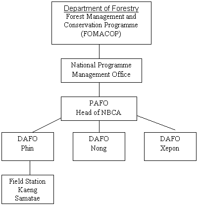
Management History:
Since October 1996, the Forest Management and Conservation Programme (FOMACOP), a joint undertaking of the Government of Lao PDR (GoL), the International Development Association (IDA) of the World Bank, the Global Environmental Facility, and the Government of Finland through FINNIDA, has been assisting the Lao government in the Management of Dong Phou Vieng NBCA. |
|
Physical
Features |
|
|
Elevation |
200 m - 600 m asl. with peaks up to 1254 m asl. |
Climate |
Dong Phou Vieng lays in the Southeast Asia monsoon climate. During the winter (November – February), when the sun is to the south of the equator the climate is under the influence of the cold continental high pressure region over China. The winds are clockwise around the high and come from the northeast over Southeast Asia. This is the Northeast Monsoon, characterized by cold dry air and infrequent light rain.
For the summer (May – August), the sun is to the north of the equator and heats the land mass beneath to a degree that causes an extensive low pressure region called Intertropical Convergence Zone and the Monsoon Trough. Warm winds from the southwest carry moisture from the Andaman Sea and the Gulf of Thailand to the part of the trough in the Lao PDR region where vertical convection causes rainfall, large amounts during the height of the monsoon season. This is the Southwest Monsoon. The air is warm and humidity high. |
Main Forest
Types |
|
|
Forest Cover
This calculation was realized by the Forest Cover Monitoring Project (FCMP) MRC / GTZ. It is based on interpretation of 1996/97 Landsat TM with the NBCA boundaries as shown on topographical maps 1:100 000 provided by the FOMACOP project. Verification with the original documents has not taken place. Therefore the data might be only approximate.
| Forest Code |
Area / ha |
% of Total Area |
| Evergreen / Mixed, Continuous Cover, High Cover Density (11, 17) |
12.565 |
5,7 |
| Evergreen / Mixed, Continuous Cover, Medium Cover Density (12, 18) |
71.765 |
32,7 |
| Evergreen / Mixed, Mosaic (13, 19) |
27.019 |
12,3 |
| Deciduous Continuous Cover (20) |
12.591 |
5,7 |
| Deciduous Mosaic (22) |
16.807 |
7,6 |
| Regrowth (40) |
1.154 |
0,5 |
| Evergreen Wood and Shrubland (61, 63, 65) |
39.973 |
18,2 |
| Grassland |
506 |
0,2 |
| Mosaic of Cropping (81, 82) |
33.426 |
15,2 |
| Agricultural Land |
4.268 |
1,9 |
| Grand Total |
220.076 |
100,0 |
|
Other Habitat
Features |
|
Recorded
Vertebrates |
Vertebrate Class |
No. of species |
Key species |
Mammals |
32 |
8 |
Birds |
186 |
6 |
Reptiles |
42 |
? |
Amphibians |
16 |
? |
Fish |
100 - 300 |
? |
|
|
Biodiversity
Values |
Exceptional aquatic diversity
-
Shrub / rhododendron vegetation
-
Significant populations of: Gibbon, Douc Langur, Gaur, Giant-Muntjak, Dhole, Jackal, Tiger, Pangolin
-
Two herds of elephants
-
Three species of hornbills: Oriental Pied Hornbill, Great Hornbill, Wreathed Hornbill
-
Two species of vultures: White-rumped Vulture, Red-headed Vulture
-
Economically important, apparently endemic calanoid crustacean species, not yet identified.
|
Watershed
Values |
Many tributaries to the Xe Banghiang and Xe Lanong, which are crossing the NBCA
-
Watershed for the Xe Chon, which originates in Dong Phou Vieng NBCA and flows along its western boundary with many tributaries entering it from Dong Phou Vieng NBCA.
|
Cultural
Values
Security
Values |
|
Recreation &
Tourism
Values |
Authentic indigenous Lao Teung culture with strong spiritual ties to the land
-
Five different "Lao Teung" languages are spoken, of which at least two are in danger of extinction.
-
Several spiritual forests
-
Indochina War relicts
-
Part of the Ho Chi Min Trail
-
Ruins of a bridge destroyed by the Americans
|
Principal
Threats
Reasons for
Extensions or
Excisions |
Hunting and capture of animals
-
International animal trade encouraging the poaching of animals from the NBCA, especially:
-
reptiles ( pythons, King cobra, other snakes and turtles)
-
pangolins
-
Destructive fishing methods:
-
explosive fishing
-
chemical fishing
-
electrical fishing
-
Human population increase
-
Expansion of paddy fields
|
|
Contact |
Mr. Pouthavong Sitthidet
Forest Management and Conservation Programme (FOMACOP)
National Biodiversity Conservation Area Management Sub-Programme
Savannakhet, Savannakhet Province, Lao PDR; Tel. / Fax: 041 – 212 971 |
Staffing |
Staff is from the Province Agriculture and Forestry Office (PAFO) of Savannakhet Province and the District Agriculture and Forestry Offices (DAFO) of Phin, Xe Pon and Nong districts.
| |
Men |
Women |
Total |
| PAFO Savannakhet |
3 |
|
3 |
| DAFO Muang Phin |
8 |
1 |
9 |
| DAFO Muang Xe Pon |
1 |
|
1 |
| DAFO Muang Nong |
2 |
|
2 |
| Short term staff |
3 |
|
3 |
| Total |
17 |
1 |
18 |
|
Buildings |
One room in the office building of the Forest Management and Conservation Programme, Savannakhet
-
Field stations including offices and dormitories in Muang Phin and Keang Samatae
|
Equipment |
Two 4WD vehicles
-
Seven motorcycles
|
Organization |
|
Current
Management
Priorities |
|
Other
Management
Opportunities |
- Development of sustainable practices for NTFP use by the local villagers
- Development of small scale enterprises
- Development of tourism based on the tourist values of
- Landscape
- Authentic indigenous cultures
- Historical war relicts
- Participation of local villagers in monitoring of
- Wildlife populations
- Habitat changes
- Trends in NTFP presence
- Trends in NTFP use
- Trends in fish population seize
- Fishing with destructive methods by outsiders
- Poaching
- Documentation of the indigenous knowledge
- Stabilization of slash and burn agriculture
|
Other
Project
Initiatives |
CIDSE: Phine Self-help Rural Development Project
-
DAMIEN Foundation Belgium Support of National Tuberculosis Program (Phine district)
-
Handicap International: Capacity building of UXO LAO for the clearing of UXO operations (Phine and Nong districts)
-
Norwegian Curch Aid: Integrated Rural Development Program.
|
|
| |
Baird, I.G. (1998). A Preliminary Assessment of the Aquatic Resources of the Dong Phou Vieng Biodiversity Conservation Area, and its Proposed Expansion Area, Savannakhet Province, Lao PDR. In: Rapid and Participatory Biodiversity Assessments (BIORAP) in Dong Phou Vieng Protected Area, Final Report, WWF –Thailand Project Office, p. 69 - 82
Caffery, B. (1998). Conservation and Development. Final report of the period of consultancy from 28.9.2024 to 11.6.1999. FOMACOP (76 pp.)
Chan-ard, T. (1998). Preliminary Survey of Amphibians and Reptiles in Dong Phou Vieng Reserved Forest, Savannakhet Province, Lao PDR. In: Rapid and Participatory Biodiversity Assessments (BIORAP) in Dong Phou Vieng Protected Area, Final Report, WWF –Thailand Project Office, p. 93 – 97.
Falke, M. (1999). The Geological Conditions of Dong Phou Vieng National Biodiversity Conservation Area, Savannakhet Province (4 pp.).
National Statistical Centre, State Planning Committee (2000). Population Census Results 1995, Savannakhet Province, Districts: Phin, Xe Phon and Nong (These data, which are available normally only on diskette, have been printed out for Dong Phou Vieng NBCA).
Thonongto, S. (1998). Status of Birds in Dong Phou Vieng National Protected Area, Lao PDR. In: Rapid and Participatory Biodiversity Assessments (BIORAP) in Dong Phou Vieng Protected Area, Final Report, WWF –Thailand Project Office, p. 89 – 92.
Rapid and Participatory Biodiversity Assessments (BIORAP) (1998) in Dong Phou Vieng Protected Area Final Report, WWF – Thailand Project Office, 97 pp.
Steinmetz, R. (1998). A Survey of Habitats and Mammals in Dong Phou Vieng National Biodiversity Conservation Area, Savannakhet Province, Lao PDR. In: Rapid and Participatory Biodiversity Assessments (BIORAP) in Dong Phou Vieng Protected Area, Final Report, WWF –Thailand Project Office, p. 22 – 43.
Steinmetz, R. and Baird, I.G. (1998). Participatory Biodiversity Assessment of Dong Phou Vieng Protected Area, Savannakhet Province, Lao PDR. In: Rapid and Participatory Biodiversity Assessments (BIORAP) in Dong Phou Vieng Protected Area, Final Report, WWF –Thailand Project Office, p. 44 – 68
Wagenbreth, I., Sithideth P. and Tonlaontha, K. (1999). Dong Phou Vieng National Biodiversity Conservation Area: Population Census Data 1995 (10 pp.). |
| go up |
|