Trek through rice fields of Luang Namtha and into the forested foothills beyond during a reasonably gentle day's walk. The trail passes through the villages of Ban Don Kone, Ban Nam Hoi, Ban Piang Ngam and Ban Nam Ngean.
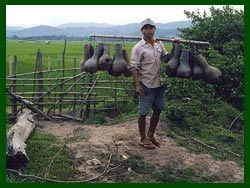
Learn about the lifestyles of these different communities, and observe traditional agricultural practices, community forest use, sericulture and silk weaving as well as the distilling of Lao Lao (rice whiskey). Enjoy a typical local lunch with villagers in Ban Piang Ngam.
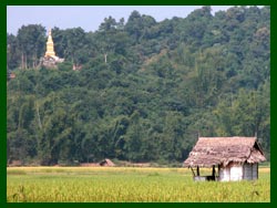
The trek ends with a visit to Ban Nam Ngean and the remains of That Poum Pouk stupa before trekkers are met by a tuk-tuk and return to Luang Namtha.
The Hmong and Mien (also called Yao ) ethnic groups belong to the Hmong-Mien language family. They are the most recent arrivals to Southeast Asia, having left their homeland in southern China. Today Hmong and Yao communities have settled around the world: Myanmar , northern Thailand , northern Laos, Vietnam , the United States and France.
The Hmong traditionally live in upland communities, where they practice swidden agriculture, cultivating rice, corn, vegetables and legumes and raising pigs and other small livestock. They practice a combination of animism and ancestor worship. If invited into one of the villager's houses, you may notice a thin pole for the house spirit and a small wall-mounted altar for the ancestors' spirits. Around the village you may also see seasonal activities or handicraft production,
Tai groups dominate the plains of Luang Namtha Province . They include the Lao, Tai Yuan, Tai Lue, Tai Neua, Tai Dam, Tai Daeng and Tai Khao. Members of the Tai linguistic family, they speak languages which are very similar, marked only by minor variations. The Tai are distinguished by their advanced political organization, called muang in Tai. The muang was a kind of principality or kingdom ruled by a hereditary elite class, and usually encompassing the land in one valley.
Tai groups practice wet rice agriculture, cultivating glutinous (sticky) rice. Some groups also practice swidden agriculture. All Tai women dress in sin, long tubular skirts, with ethnic differences expressed through the design and weave of their costumes. Highly skilled in producing textiles, some Tai groups practice sericulture and weave in silk, while others weave in cotton.
This was the earliest Tai group to settle in the Luang Namtha Valley, moving here from the Lanna Kingdom in northern Thailand in the 16th century. The Tai Yuan are Theravada Buddhists coupled with a belief in pre-Buddhist spirits.
These subgroups of the Tai linguistic group are a different kind of Tai. They originated from the Dien Bien Phu area of northern Vietnam, spreading westward into the area which is today Laos. Although these groups also form powerful muangs, they never converted to Buddhism. Instead, they practice a form of animism or spirit worship that includs veneration of the powerful spirit of the muang, village and house.
The hills surrounding Luang Namtha valley are forested by areas known as Village Use Forests. Management of these areas is the responsibility of those living in adjacent communities. Villagers rely on their forest areas to provide essential products such as timber and rattan for housing, and they also supplement their diet and income by hunting small animals, as well as collecting and selling non-timber forest products such as cardamom.
However, pressure from an increasing population threatens the integrity of these areas. Giving local people direct responsibility for the management and protection of these vital tracts of land will help to ensure their existence for future generations.
According to historical sources, the That Poum Pouk stupa was constructed as part of a competition between the Lanna Kingdom (based in what is now northern Thailand), and the Lane Xang Kingdom (based in what is now Luang Prabang). The competition was born out of a desire to prove which kingdom had the most merit.
The stupa was bombed twice during the Second Indochinese War. The first time was in 1964 and villagers and monks in the area were able to restore the stupa. However, the second bombing in 1966 destroyed the two upper stories leaving only the ground level. Every year in February, villagers from three nearby villages clear away overgrown vegetation and a special Buddhist ceremony takes place there.
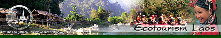
Day treks go to the ethnic Hmong and Tai Daeng/Tai Kao villages everyday. The trek can be extended into an overnight trip with a stay in the Piang Ngam village guesthouse. Overnight stays include a gift from the village (typically a locally produced scarf or towel).
Groups with less than 4 perosns must pay for 4 persons.